About District
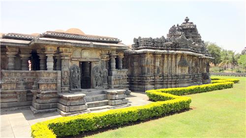
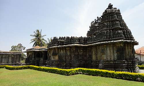
Hassan District is one of the 30 districts of Karnataka state located in the south-western part of Karnataka in India. The district has had an eventful and rich history. In the past, it reached the height of its glory during the rule of the Hoysalas who had their capital at Dwarasamudra, the modern Halebeed in Belur Taluk. The district, noted for its enchanting natural scenic beauty is also a veritable treasure-house of Hoysala architecture and sculpture, the best specimens of which are at Belur and Halebeed. Shravanabelagola, in Channarayapatna taluk, which is studded with Jain moduments, is a renowned centre of pilgrimage for the jains.
Origin of Name
Like most of the other districts in the State, this district also derives its name from its headquarters town, Hassan. According to the Sthalapurana, the name ‘Hassan’ is a contraction or derivative of ‘Simhasanapura’, associated with janamejaya, a great grandson of the Pandava hero, Arjuna. But the popular belief is that the place is called Hassan after the goddess Hassan-amma or Hasanamba, the presiding deity of the local Hasanamba temple situated in the old town area. Hasanamma or Hasanamba means, in Kannada, a smiling mother or goddess. In this connection, a traditional story, as to how the goddess Hasanamba came to be established at this place, is narrated thus : The Saptamatrikas (seven mothers or goddesses), in the course of their journey from Varasasi (Kashi) to the South, were pleased with the scenic splendour of this area and decided to make it their abode. Accordingly, of the seven mothers, who were sisters, three settled at Hassan and another three in a tank called Devigere, also in Hassan proper, and were called Hasanamba, while the other one settled in a forest near Kenchammana-Hosakote in Alur taluk and was called Kenchamba.
GEOGRAPHICAL AND HISTORICAL IMPORTANCE OF HASSAN DISTRICT
GEOGRAPHY:- Lying between 12° 13´ and 13° 33´ North latitudes and 75° 33´ and 76º38´ East longitude, Hassan district has a total area of 6826.15 Sq. Kms. The greatest length of the district, from south to north, is about 129 kilometers, and its greatest breadth, from east to west, is about 116 kilometers. The District which has 8 taluks 38 hoblies & 2369 villages. The geographic area of the district of Hassan is 6845 square kilometers. The population is 15.67 lakhs and the average rainfall is about 1031 mms annually. Coffee, Black Pepper, Potato, Paddy and Sugarcane are the major agricultural crops. Hassan district lies partly in the “malnad” tract and partly in the southern “maidan”(plains) tract. By considering the physical aspects, climate, rainfall, etc. the district may be divided into three regions, viz., (1) southern malnad, (2) semi-malnad and (3) southern maidan. western and north-eastern portions of the Belur taluk, western and central parts of Alur taluk and the whole of Sakaleshapura taluk constitute the “southern malnad” region, the central parts of the Arkalgud taluk, the western portion of the Hassan taluk, the eastern portion of the Alur taluk, the central and eastern parts of the Belur taluk and the western parts of the Arasikere taluk form the “semi-malnad” region. The southern maidan region includes the whole of the Holenarasipura and Channarayapatna taluks, eastern parts of the Arasikere and Hassan taluks and the south-eastern portions of the Arkalgud taluk. The southern malnad is a forest-clad hilly region with a heavy rainfall.
POPULATION AND GROWTH TRENDS:
As per the 2001 census the population of Hassan district is 17,21,669. Out of which 14,16,996 is the rural population and 3,04,673 is urban population. The percentage of rural and urban population to the total population of the district is 82.31 and 17.69 respectively. The percentage of rural and urban population to the total population according to 1981 census (1357014) was 85.37 and 14.62 respectively. Between 1981 to 1991 there is an increase of 2.76 percent in urban population. The decadal growth rate works out to 15.67 percent (1981-91). The decadal growth rate was highest between 1951-61 and it was 25.57 percent. It reduced to 23.05 percent during 1961-71, increased to 23.10 percent during 1971-81 and reduced to 15.67 percent during 1981-91. There is a decrease in 7.43 percent of growth in population between 1981-91. The district has a balanced male, female ratio (996) as per 2001 census. The density of population varies considerably amongst the taluks. With a density of 385 persons per sq.km Hassan taluk tops the list and this is followed by Arkalgud (295), Holenarasipura (290), Channarayapatna (266), Arasikere (238), Belur (217), Alur (199) and the lowest density of 129 persons per sq.km is noticeable in the case of Sakaleshapura taluk according to 2001 census. The density of population per square kilometer for the district is 251.
Hassan District, in the Mysore region is a district of Karnataka with its administrative headquarters located at Hassan city. According to 2011 census, the district encompasses a geographical area of 6814 sq km and has a population of 17,76,421 (persons) including 8,83,667 (males) and 8,92,754 (females). The district has a sex ratio of 1010 (females for every 1000 males. The major religions in the district are Hindu (91.80%) and Muslim (6.76%) of the total population respectively. The literacy rate in the district is 76.07% (persons), 83.64% (males) and 68.60% (females). Main spoken languages are Kannada (87.04%), Urdu (6.16%), Telugu (1.96%). Labour Force participation Rate is 61.37% for the year 2017-2018. Main source of income in the district is from the agriculture sector and per capita income is Rs. 127229. The crime rate in the district is 281.07 for the year 2018. Total cropped area is 3,64,071 in hectares and the forest area is 1478.44 in sq km (2019).

14 Comments
Comments are closed.